The effects of climate change can already be felt in the City of North Vancouver – temperatures are higher, winters are wetter, summers are drier, and extreme weather events are becoming more common.
Extreme and damaging events – like the floods caused by heavy rainfall in Spring 2018, severe storm in Winter 2018 and the record-breaking forest fires and poor air quality of Summers 2017 and 2018 – will become increasingly common in the coming decades.
Our health, buildings, infrastructure, environment, and quality of life will all be severely impacted if we are not prepared for the coming changes.
Climate Change Adaptation Plan
 To respond to these challenges the City of North Vancouver adopted the Climate Change Adaptation Plan in October 2013.
By improving the City’s capacity to respond to the effects of climate change we will not only help to avoid the most severe impacts, but also reduce costs and make the City a better place to live.
Because climate change will affect nearly all aspects of life, the City has also made the strategic decision to integrate adaptation throughout all City operations, including the 2014 Official Community Plan (OCP).
By adopting adaptation as a key priority and committing to action through the OCP and Climate Change Adaptation Plan, the City continues to show its commitment to sustainability, community vitality, and climate leadership.
The City is following the Building Adaptive and Resilient Communities (BARC) Program to plan for the impacts of climate change.
What Are We Doing to Adapt?
Integrated Stormwater Management Planning
Flooding due to intense rainfall is one of the greatest climate change risks the City faces. As large storms become more frequent and powerful, traditional stormwater management that relies on storm sewers and engineered waterways will lead to skyrocketing costs, environmental damage, and will still leave us at risk.
This City is following new approach, called Integrated Stormwater Management Planning (ISMP), to reduce stormwater at the source by allowing rainwater to seep into the ground, rather than just transporting it away in storm sewers.
Please go to
Rains, Drains, and Creeks for more information.
Flood Construction Levels
Flood construction levels (FCLs) are used to ensure that businesses, living spaces, and storage areas (including electrical and mechanical equipment) are built high enough to prevent flooding.
In July 2014 the City raised its FCL from 3.25m to 4.5m to provide enhanced protection from the risk of flooding. Although this increase does not account for sea level rise (SLR), it is a substantial change that brings the City in line with the best practices for the current sea level. The higher FCL also greatly reduces barriers to implementing future sea level rise management strategies and increases the City’s resilience to extreme weather today and in the future.
Hazard Land Development Permit Areas
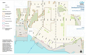
 Adopted as part of the 2014 Official Community Plan, the Hazard Lands DPA identifies lands within the 200-year flood plain and areas near steep slopes, and requires that landowners obtain a Development Permit before proceeding with any development or alteration. These areas are at the most risk to increasingly extreme weather. By ensuring any development on these lands is adapted to the climate of the future will help to minimize risks to both property and life.
Green Building Amendments
The City of North Vancouver is committed to building a more sustainable community and amended the City's Zoning Bylaw to support the construction of greener buildings. Not only will it be easier to design and build green, but the City has introduced new incentives and requirements for all new construction. There are now more opportunities to include higher energy efficiency, waste and water diversion, local food production and healthy living environments into construction design.